HOME | CONTACT STCL | TRAIL MAP AND CONSERVATION PLAN
-SPECIAL ECOLOGICAL SITES OF THE ROBSON VALLEY REGION
-SUGGESTED HIKING AND DRIVING GUIDELINES
SPECIAL ECOLOGICAL SITES OF THE ROBSON VALLEY REGION
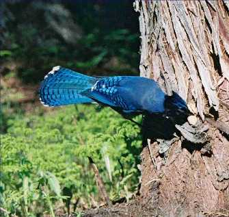
This ecoguide is intended to bring public attention to the biological, ecological, recreational, and spiritual richness of the ancient old-growth Western redcedar rainforest of the Robson Valley Bioregion. We hope to instill a sense of stewardship in ecoguide users that will ultimately lead to the protection of this extremely sensitive, ecologically significant, world-class rainforest and the surrounding mountains. The ancient old-growth cedar rainforest of the Robson Valley is the world's most extensive inland rainforest at temperate latitudes and contains ancient trees whose ages exceed 1200 years. Save-The-Cedar League's mission is to provide education that will lead to the protection of this unique rainforest.
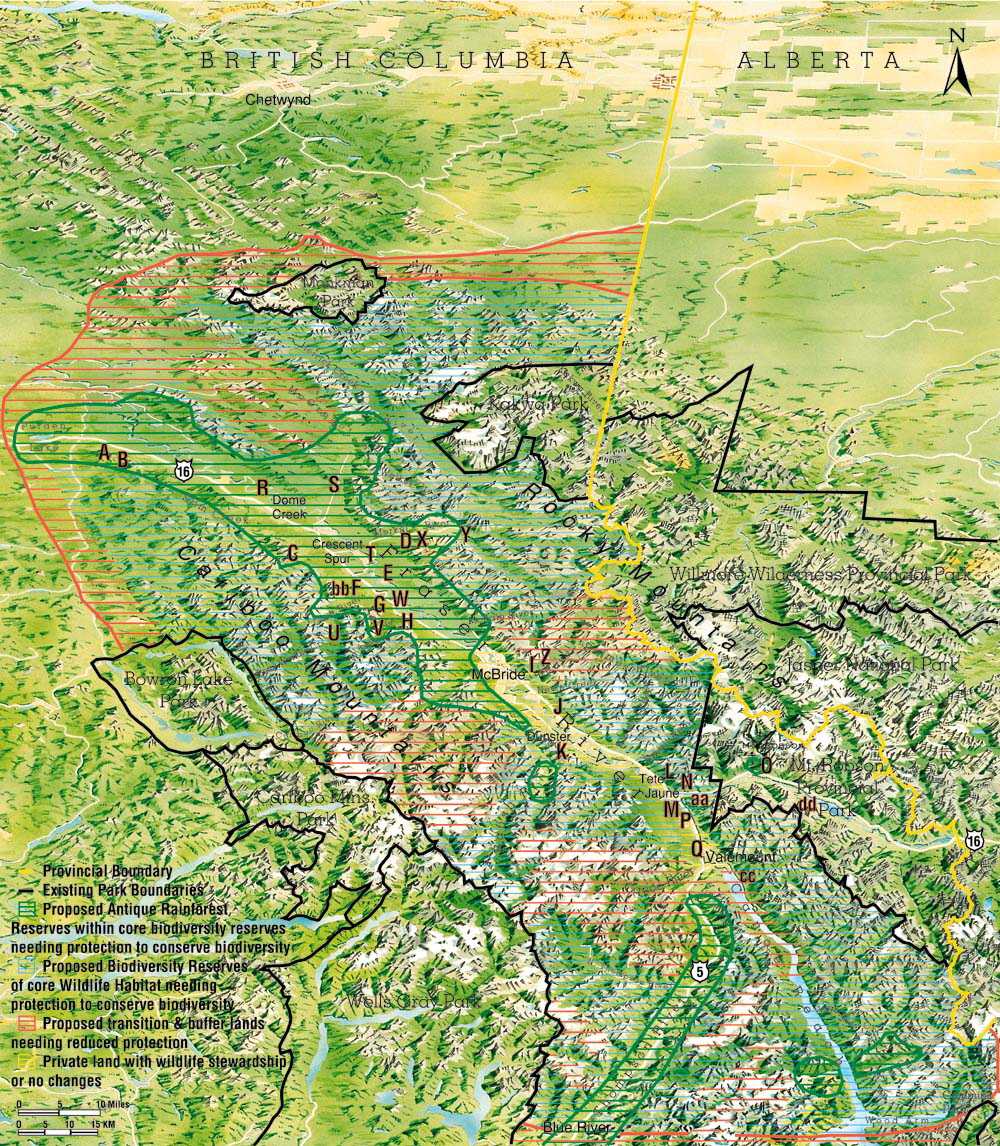
In addition to old-growth cedar rainforest sites, other significant places of the Robson Valley Bioregion are also featured in this ecoguide. As you experience this splendid old-growth cedar rainforest keep in mind the "living link" of the past to the present this forest represents. Help us to ensure that this "living link" continues long into the future by joining or donating to STCL (8995 Loos Road, Crescent Spur, British Columbia, V0J 3E0, (250) 553- 2325). We also provide ecotours with professional ecoguide escorts who will teach you more about the ecology of each area at reasonable rates. Wilderness, mountain, dune, dry-forest, alpine, riparian, salmon, waterfall, wetland, and other sites are featured below and mapped on the true-to-life TRAIL MAP AND CONSERVATION PLAN. The panoramic trail map shows the areas that need to be protected to conserve the magnificent biodiversity, the world-class old-growth, and the quality of special sites of the Robson Valley Bioregion.
SUGGESTED HIKING AND DRIVING GUIDELINES
Leave your route with someone when venturing into outlying areas.
Adequate clothing and footwear is essential. We suggest warm clothing, rainwear, and sturdy, comfortable, water-resistant footwear.
Bring food and water for hikes of 1 hour or more. Do not drink water from streams or rivers, they may contain Giardia, viruses, herbicides, or bacteria.
Carry out what you carry in. Never leave litter behind. Pick no flowers.
Additional items you may want to bring with you include insect repellent, binoculars, camera, compass, field guides, and a first-aid kit.
Forest service logging roads may have active logging. Follow directions on signs at the beginning of these roads or phone the Forest Service at (800) 345-5115.
Do not feel limited by the absence of trails at the old-growth driving sites. A brief walk into the forest from your vehicle is rewarding, refreshing, and educational.
Bring this ecoguide with you on your journeys throughout the Robson Valley Region and keep a record of the animal species you encounter by checking the boxes on each checklist.
Mileages and descriptions are approximate. Conditions may change, so allow yourself extra time to do the hikes and drives, and do not take unnecessary chances on bad roads.
Notify STCL at (250) 553-2325 for help you may need, exceptional species you see or hear, trail changes, or other observations.
Trails featured correspond to letters on the panoramic map in this ecoguide and range in difficulty from an easy stroll to more strenuous efforts. Trails are rated as:
Easy: Generally suited for families with children and elder folk.
Moderate: Suitable for individuals in good physical condition.
Difficult: Suitable for people in very good physical condition.
#km: Designates approximate round-trip hike length.
A. SUGAR BOWL RIDGE TRAIL: Moderate/18km. Located about 79km east of Prince George on Highway 16. The trailhead is found on the right (south) side of the highway. A small sign marks the entrance to a parking area and trailhead. After reaching the ridge at 5km the trail continues and eventually connects to the Viking Ridge Trail (B. below), forming a 16km semi-circle route back to Highway 16. Watch for caribou and grizzly bear sign.
B. VIKING RIDGE TRAIL: Moderate/13km. Located about 85km east of Prince George on Highway 16. The trailhead is found on the right (south) side of the highway. Look for a trail sign from the highway, on top of a large bank. A small parking area is located across the highway from the trailhead. Large old-growth cedar will be found on the first 3km of this trail. The trail then ascends through stands of cedar, hemlock, spruce, and subalpine-fir to meadows, lakes, and steep slopes. Caribou and grizzly bear sign are always found.
C. ERG MOUNTAIN TRAIL: Difficult/12km. Located off Highway 16 about 10km west of Loos Road. Turn south onto a gravel road with a small trail sign on the highway. Drive 5km on this road until you reach the campsite on Ptarmigan Creek. Cross the footbridge over the creek and follow the old gravel pit road about 2km until you reach the Erg Mountain Trail sign in a grove of Western hemlock. The trail eventually becomes very steep and ascends into a mixed forest of cedar, hemlock, spruce and subalpine-fir. Watch for grizzly bear sign.
D. MORKILL OLD-GROWTH CEDAR TRAIL: Moderate/8km. From Highway 16 go 7km on Loos Road (north) to the Morkill Forest Service Road (FSR) on the right (north). Travel the Morkill FSR for 10km. After driving 2/3 through a large clearcut that started at 10km, there will be a small clearcut hill at 11km on your right (east). The trailhead is on the east end of the clearcut, on the north side of the base of the small clearcut hill. Park on the right (east) side of the road and walk through the clearcut towards the small clearcut hill, with a spruce-fir-cedar forest edge on your left (northeast) until you come to a magnificent cedar grove at the trailhead. This trail is in a v-shaped valley with large cedar on all sides, and huge devils clubs along a small stream.
E. MOUNTAIN LION CEDAR TRAIL: Moderate/10km. Located near Crescent Spur at 1km on the Morkill FSR (see D. MORKILL OLD-GROWTH CEDAR TRAIL above for directions to Morkill FSR). As soon as you cross the Fraser River bridge at 1km you will see a gravel road on your right (east). The trail begins on the hill just to the left (north) of this gravel road in the forest traveling parallel with the Fraser River. This is an impressive trail with large trees of several species, rock outcrops, views of the Fraser River, and groves of very large, old cedar (over 12 feet in diameter, after 2km). Look for deer, moose, wolf, cougar, and fisher sign, and a large variety of birds.
F. GOAT RIVER CANYON TRAIL: Moderate/8km from highway. Located off Highway 16 about 8km east of Loos Road. The trail is accessed by an old road on the right (south) side of Highway 16, 1/2km before the Goat River bridge and rest area. The old road is easily missed by those driving on Highway 16, because of the steep drop it takes off the highway. It is best to park at the Goat River Rest Area and walk west on the left (south) side of Highway 16 to spot the access road. This is a 4-wheel drive road at the best of times which turns into a hiking trail at about 2km. Thousand year-old large cedar with silver tree bark, moss covered forest floor, salmon spawning grounds, and the Goat River rock canyon end-point make this a very special trail. Watch for grizzly and wolf sign plus a large variety of birds.
G. BOULDER MOUNTAIN TRAIL: Moderate/16km. Drive 12km on Highway 16 east of Loos Road until you come to the Goat River FSR on your right (south). Follow the Goat River FSR about 2km and park where an old road marked with a trail sign leaves to the left (east). The trailhead is located about 2km up this old road and is marked with a sign on your left (east). There are large cedar and a stream at the beginning and then the trail ascends through cedar, hemlock, spruce, and subalpine fir into an alpine meadow. On clear days there are good mountain views. Watch for blueberries and huckleberries.
H. WEST TWIN CREEK OLD-GROWTH TRAIL: Easy/4km. Located off Highway 16, about 1km east of the Highway 16 bridge over West Twin Creek (see V.). You will see an old road, parking lot and trail sign on your right (south) at the trailhead. Large cedar and hemlock, and easy walking make this a trail everyone should see. Watch for caribou, grizzly bear, and black bear sign.
I. BEAVER/HOLMES RIVER FALLS TRAIL: Easy/2km. The signed trailhead is located off Highway 16, about 11km east of McBride, before the Highway 16 bridge over the Beaver/Holmes River. The trail travels upstream along the north side of the Beaver River. A falls is located within 1km of the parking area. Watch for Douglas-fir forests, salmon, and black bear.
J. NATURAL ARCH TRAIL: Difficult/9km. Located about 22km east of McBride on the north side of Highway 16 along Baker Creek. Just after passing a rest area on your right (south) there will be a road leaving Highway 16 to the left (north). The marked trailhead is within 1km up this road on the right (east). This road can be considered a 4-wheel drive road so you may want to park your vehicle and walk to the trailhead. An impressive stone arch can be viewed from the ridge at the top. Watch for grizzly bear, black bear, and mountain goat sign. Many species of birds and bats can also be found.
K. DUNSTER TRAIL: Difficult/8km. From Highway 16 turn right (south) onto the Dunster access road 29km east of McBride. Follow this road about 4km until it ends at a "T". Turn left (east) and immediately turn right (south) onto Pepper Pit Road. Follow this road 2km to the gravel pit at the end. The trail starts at the top of the pit and is steep all the way to the alpine. There are good views from the top on clear days of the Raush River watershed (the largest undeveloped, unprotected watershed left in the southern half of BC).
L. SPITTAL CREEK: Easy/2km. Located on the north side of Highway 16 about 7km west of the junction of Highways 5 and 16. There is a sign on the highway at the parking area. This is a self-guided interpretive trail and a pleasant walk through an old Douglas-fir forest along the rushing Spittal Creek.
M. TETE JAUNE CACHE/McCLENNAN RIVER SPAWNING GROUND TRAIL: Easy/3km. About 1km west of the junction of Highways 5 and 16 turn south onto Blackman Road, cross the Fraser bridge, and turn right (west) onto Old Tete Jaune Road at about 3km. Cross the railroad tracks at 2.5km and take the first gravel road on the right (north). This road leads to the spawning ground site. There will be a sign denoting the spawning grounds. Watch for elk, deer, moose, and a large variety of birds.
N. LOST LAKE TRAIL: Moderate/6km. From Tete Jaune Cache, at the junction of Highways 5 and 16, go about 2km east on Highway 16 and park at the (second) rest area on the right (south), about 1km east of the weigh scales. Cross the highway at the west end of the rest area and you will find a sign at the trailhead. This trail leads through old Douglas-fir to a small, beautiful lake at 1.5km in a canyon with mountain and cliff viewscapes and two lookouts. Watch for waterfowl, beaver, muskrat, and warblers.
O. KINNEY/BERG LAKE TRAIL: First 5km (one-way) easy, the rest is difficult/44km round trip. Located in Mount Robson Provincial Park, this trail travels along the Robson River through an old-growth cedar/hemlock forest, a mix of spruce and fir, and some alpine meadows to Kinney Lake at 5km. If you decide to hike the entire trail, plan on taking at least 4 days. The trail travels past lakes, waterfalls, and hanging glaciers ending at Berg Lake.
P. JACKMAN FLATS: Easy/many kilometers of flat trail. Located about 6km south of the Highway 5 and 16 junction off of Highway 5. A sign denoting Jackman Flats can be seen on the right (west) side of Highway 5. You can choose from 5 trail loops varying in length from 1-6km or a 2km long interpretive trail from the parking area. Jackman Flats contains a unique assemblage of vegetation in a pine forest growing on sand dunes. Much care and effort went into making this trail system. It is educational and enjoyable. Be extremely careful not to miss or step on the many rare species of plant life. Many birds and mammals will be encountered.
Q. VALEMOUNT SALMON SPAWNING VIEWING AREA: Easy/very short walk. Located off Highway 5 in Valemount on Swift Creek. Instead of turning east off of Highway 5 into Valemount centre turn west at the same intersection and then immediately turn right (north). Follow the signs and go 1/4km to the spawning grounds and footbridge at the edge of a paved parking area.
R. DOME CREEK ACCESS ROAD: Located about 36km west of Loos Road. Turn north onto the Dome Creek access road at the Dome Creek Diner. The first 5km of this road is one of the nicest drives through an old-growth cedar/hemlock forest in the Robson Valley. A 4-wheel drive road leads through other very impressive old-growth cedar/hemlock stands beginning at the Dome Creek waste disposal site (the first left (west) off of the Dome Creek access road).
S. WALKER CREEK FOREST SERVICE ROAD: Located about 21km west of Loos Road leaving Highway 16 to the north. The Walker Creek FSR has been heavily logged but one can still find stands of old-growth cedar/hemlock at 7km and between 10-20km along the road. There are also viewscapes of cedar/hemlock forests reaching up the mountain sides along this road. Watch for grizzly bear on the road and salmon at 22km.
T. MORKILL FOREST SERVICE ROAD: See D. MORKILL OLD-GROWTH CEDAR TRAIL for directions. The first 25km of the Morkill FSR is an ecologically rich assemblage of old-growth cedar/hemlock, spruce/fir, and deciduous forests with high wildlife values and intact riparian zones. Viewscapes include old-growth cedar/hemlock forest, the Morkill River, and fabulous mountain scenes. Watch for moose, deer, black bear, raptors, and many aquatic species on oxbows and the Morkill River. Mountain goat and grizzly bear can be observed on the slopes to the north beginning at 12km.
U. GOAT RIVER FOREST SERVICE ROAD: See G. BOULDER MOUNTAIN TRAIL for location of Goat River FSR. Stands of old-growth cedar/hemlock are viewable close to the road between 2-4km and 5-14km. Panoramic viewscapes of old-growth cedar and hemlock are also seen from the road across the Goat River to the north.
V. WEST TWIN FOREST SERVICE ROAD: Located on the south side of Highway 16 about 18km east of Loos Road and 2km west of the Highway 16 bridge over West Twin Creek. The gravel road on the right (south) while heading east on Highway 16 travels through an old-growth cedar/hemlock stand containing large specimens from 2-5km. The West Twin area is a Protected Area Strategy candidate and although it has been 10% logged, it is hoped that with care and time the remaining forest and wildlife populations will reestablish healthy populations. Watch for grizzly bear, black bear, mountain goat, and caribou sign.
W. LAMCO ROAD EAST/WEST: The Lamco Road old-growth can be accessed from 2 different locations off Highway 16. The Lamco Road forms a horseshoe, crossing the West Twin Creek near the centre of the horseshoe (private property). The western section of the Lamco Road is accessed about 1km west of the West Twin Creek bridge. Large cedar, hemlock, and spruce are found along the road and on short walks into the forest and many species of birds and bats may be seen.
After crossing the West Twin Creek bridge while heading east on Highway 16, the eastern section of the Lamco Road will be the first gravel road on your left (north), about 2km past the bridge. Drive the first 2km of the Lamco Road from Highway 16 to see large cedar and two old-growth streams. An unusually large diversity of tree species are found along this road, accompanied by a large diversity of birds.
X. HELLROARING FALLS: Moderate/1km. This trail is unmarked traveling along the north side of Hellroaring Creek. The trailhead is located about 19km up the Morkill FSR (see D. MORKILL OLD-GROWTH CEDAR TRAIL for directions to the Morkill FSR). Park your vehicle on the right (east) side of the road immediately after crossing the Hellroaring bridge. Follow the Hellroaring upstream into the woods up a steep hill. The trail will level off and you will find yourself in a unique old-growth hemlock forest surrounded by a very thick carpet of moss. In about 5-10 minutes you will reach the Hellroaring Falls located in an impressive canyon. Please do not step off the trail as once stepped on the moss dies. Watch your footing on the rocks at the waterfall.
Y. MORKILL FALLS: The most impressive waterfalls of the Robson Valley. Use extreme caution when viewing. Footing at the edge is bad and there is a steep drop into the falls. See D. MORKILL OLD-GROWTH CEDAR TRAIL for directions to the Morkill FSR. Drive about 34km up the Morkill FSR to a small gravel parking area on the right (east) just before crossing another Morkill River bridge. Park here and follow the short, rugged trail to the loud, main falls. Three waterfalls can be viewed from this location. The third waterfall can be seen through the forest to the left (northeast) of the waterfall directly across the river from this viewpoint. Another waterfall viewpoint is located at the end of a short but rough trail found just across the Morkill bridge.
Z. BEAVER FALLS: Travel east from McBride about 11km on Highway 16 until you cross the Beaver (Holmes) River. Turn left (north) onto the Beaver FSR just after crossing the Highway 16 bridge over the Beaver/Holmes River. Drive 1km up this road to see the falls on your left (north). Spawning salmon can be seen jumping the falls during the salmon spawning season from August to October.
aa. REARGUARD FALLS: Easy/well used. A very impressive waterfall. Go 4km east on Highway 16 from the junction of Highways 5 and 16. There is a sign on the right (south) side of the highway at the trailhead and parking area. The trail to the waterfall is about a 1km round trip. This is a popular salmon-viewing area since salmon can be seen jumping the waterfall during the salmon spawning season from August to October.
bb. LA SALLE LAKES: Drive about 3km east from the Loos Road on Highway 16. There will be a sign on your right (south) denoting the La Salle Lake road and recreation site. This is a short road traveling through remnants of a cedar/hemlock forest ending at one of the La Salle Lakes.
A smaller second La Salle Lake is accessed from a gravel parking area on the right (south) side of Highway 16, 2km east of the road to the first lake above. A short hiking trail through old-growth spruce reaches the second La Salle Lake. Watch for birds and amphibians.
cc. KINBASKET/CANOE LAKE: Turn east onto 5th Avenue into Valemount from Highway 5. Drive completely through Valemount centre and turn right (south) onto Main Street (also known as Whiskey Fill Road), after crossing the railroad tracks. Drive about 4km until you come to the Canoe Road. Turn left (east) onto Canoe Road and drive about 7km until you reach the lake. This is a very large man-made lake with gravel roads on both shores of the lake. There has been heavy logging but there are several impressive mountain views, a variety of waterfowl, and swimming mammals to be seen on the lake.
dd. MOOSE LAKE: About 30km east of the Highway 16 and 5 junction on Highway 16 in Mount Robson Park. This lake has a large variety of waterfowl. A large mud flat with shorebirds, and a series of marshes with many wildlife species are found on the east end of the lake.
RIVER/STREAM AVERAGE NUMBER OF SPAWNERS (Chinook Salmon)
| Slim Creek | 2,600 |
| Dome Creek | 300 |
| Walker Creek | 350 |
| Snowshoe Creek | 25 |
| Morkill River | 1,500 |
| Goat River | 100 |
| West Twin Creek | 50 |
| McKale River | 25 |
| Beaver/Holmes River | 1,700 |
| Nevin/King Creek | 75 |
| Horsey Creek | 150 |
| Fraser River at Tete Jaune | 4,300 |
| Swift Creek | 850 |
HOME | CONTACT STCL | TRAIL MAP AND CONSERVATION PLAN